Monday 29 September 2014

Bharatpur to Upshi... A timeless journey


Where is the time and where is Leh???


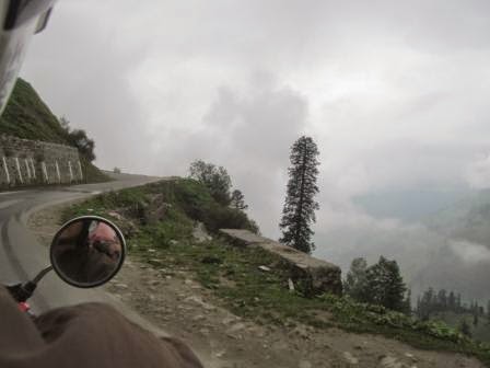
 A timeless journey indeed... This part of Manali - Leh trip leaves you wandering with your soul (because you won't be able to locate any other soul in this 240 km stretch!!! Where have all the insects gone? Is there any leaf around? No!!!).


We left Bharatpur with a motive to reach Leh that is around 285 km from Bharatpur. And we could have reached! But that's a different story. Lets first know what laid ahead (Top Secret!!!)
  
At Sarchu- Ready to leave for Leh
We left Bharatpur and after around 15 minutes of drive we thanked ourselves for staying in Bharatpur as the route is really bad with 2-3 streams which become dreadful in evening and could be crossed with too much of ease in morning at around 7 in the morning. (We were told that most dreadful streams are yet to come and we passed 3 waters of around 1cm of height and kept on fearing that something huge would come... )But there is no stream after reaching Zanskar 
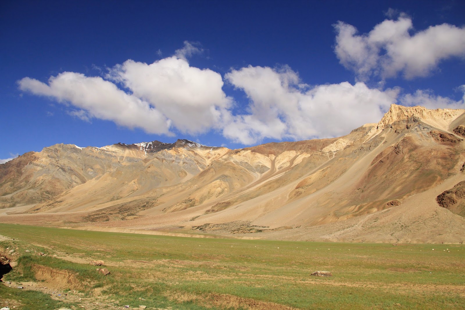
valley. At this point we leave the Himalayas and enter the plateaus of Ladakh. The shift is so immediate that you suddenly realise that there is nobody except you and your friends. Hills become barren of life or even vegetation. Here is the first time you experience the frost and loneliness of a cold desert – a vast panorama of nothing but rock and snow.


I have earlier experienced the immeasurable account of the ocean in Goa or unfathomable course of a lake (Surajtal before Baralacha la pass) or simply the majestic sky but to experience something like this with respect to land is something which can only be felt. Its probably one of the most beautiful places I have seen (I don't think anything would appear prettier to me after witnessing such varied beauty on this trip!!!)


Tents at Sarchu

At Sarchu, we got our papers checked, a small Shiv Mandir was there (And it was Shivratri. Blessed we felt!). And there we left for a journey where time loses its meaning. You just have to keep moving in the wilderness of rock, sand and snow). Although we don't  see any living being but if by any chance, you get your vehicle down in this path, try to repair it if it is morning or early afternoon, else leave it there or bring it along somehow (trucks might help) and go with fellow rider till next military camp near Pang. Because this area is habitat for snow leopards (Vikram actually saw one! Will tell later about this) and resting or to get stuck at this place in night (even with your own tent) is a bad idea.

Wilderness of rocks and sand
Last pic taken just before the fall
This seemed quite a boring journey with bad roads, too much of sun and never ending trail. We had to go some 170 km to reach Leh when suddenly Ankush lost control of the bike and we slid through the rugged road well equipped with gravel (Of all the streams, rocks or potholes,gravel is the most dangerous enemy). I was the pillion rider. Main rider can jump off the bike but pillion cannot. And as I was taking pictures, I was not wearing glove in my right hand and wearing flotters which is a sin on these roads. you must own a sturdy pair of shoes.Anyways, I got hurt badly and in extreme heat and low oxygen, started feeling unconscious. With the help of first aid box, my wounds were primarily taken care of. Then we asked for lift in a passing by truck. I travelled around 40-45 km distance in the truck while my friends were trying to repair the bike with the help of other riders. I waited for them at Pang in temporary tent.

Deserted roads to Pang

On the way to Pang
 
On the way to Pang


These pictures were taken by Vikram as I was unable to hold the camera anymore. His DSLR captured beautiful views of a deserted road. This part of the route is undoubtedly a tough one and I was so worried that I was asking every group of riders if they saw three bikes midway. Finally a group told that they have helped them and were about to reach. In around an hour they reached and all my prayers were answered.

By now, we were extremely tired and not in a condition to move ahead. We rested there and then left at around 4 in the evening. We had to travel another 173 km. A stretch of around 25 km form Pang is pure bliss. Best road and awesome beauty. Heaven! This is the pure bliss of a cold desert upto Devering. The route from Pang to Tanglang la and then further to Upshi is breathtaking (due to low oxygen;-)!!!) In fact, the road from Pang to Debring is paradise on earth. Most of the pictures available on internet are taken on this road only. But my hand did not allow me to take any pictures.

After Debring, the breathtaking climb up to the mighty Tanglang-La (17582 ft.) begins. It is around 30km stretch on a steep slope with road full of gravel. The speed came down from 90kmph to 20 kmph. In around 2 hours we reached Tanglala Pass.At the top of the pass a tiny temple and a few prayer flags flutter in the strong winds that are peculiar of this pass.

Mesmerizing Tanglang-La (17582 ft.)


Amidst the spine chilling wind, at the top of the mountain
 This is the highest pass and second motor able in the world on the way. By this time, we started feeling chilled and night was arriving. We could not stay on road, we had to reach a settlement where we could stay at night.

After that we drove all the way down to Ramsey. I being the most coward one suggested to stay there as it was already 8 in the night. But nobody listened and we rushed through the distance. Road was good and we had to reach early. 
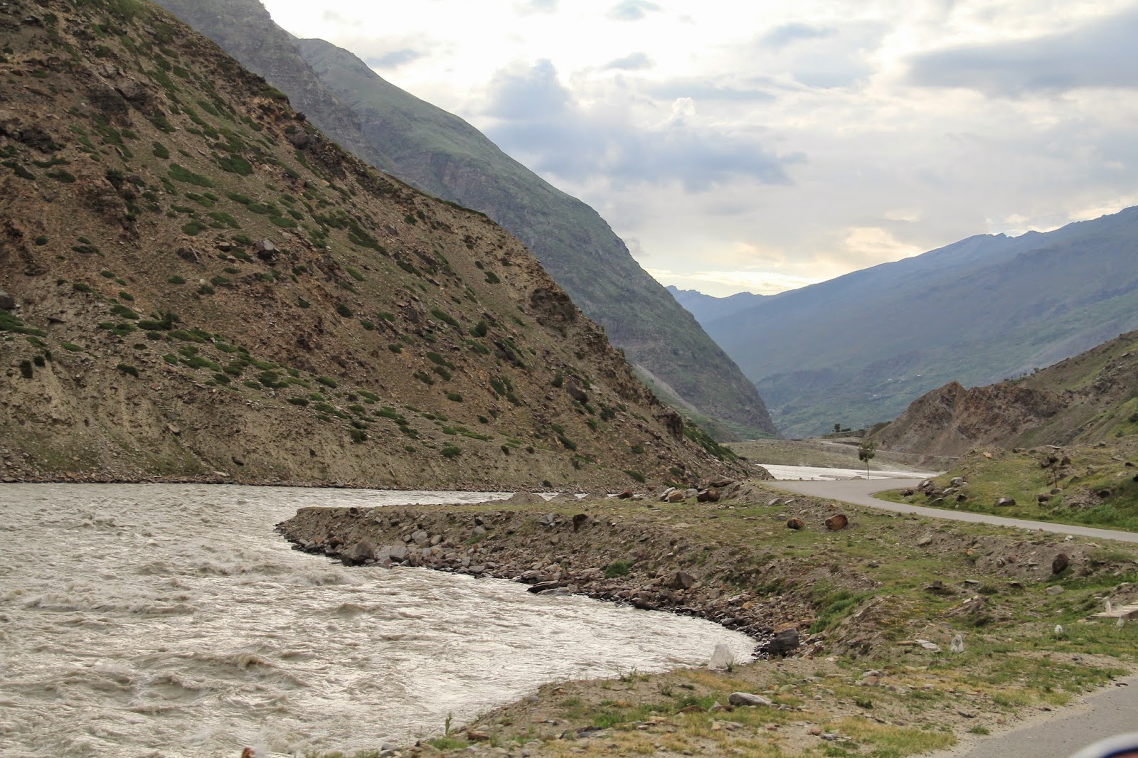
From Rumste the whole valley of the Leh region starts and road goes along the river. The road besides the river in the night is curvy but well maintained. Sound of river definitely scares and we were speeding up cautiously. Vikram being alone rode very fast. We were just 5 kms from Upshi. suddenly, we saw him coming back. All kinds of thoughts filled our minds. We stopped and asked what happened. He looked completely scared. "Lets go back. Agey snow leopard hai" was all he could say. Rumste was 26 kms back and Upshi was 5 kms. ahead with atleast one snow leopard to cross. Decided. We all geared up. All 3 bikes just rushed together with horns screaming and headlight shining bright. Within 5 minutes, we were at Upshi. We took the hotel. Fell into our bed and woke up next morning.


Saturday 20 September 2014

Day 2 - Keylong to Sarchu...

We left Keylong as per the plan... But where are all the plans?
We were at the disposal of one of the most difficult paths and most beautiful terrain... the beauty attracts and calls us ahead to reveal most exotic views but the difficulties challenge us at every move. That makes it more desirable.

One more thing... We saw so many plastic bottles and chips packets here and there. We go to Ladakh for adventure, to know the nature, to know our country not to pollute the fragile environment. It cannot bear such load. Nature has to be respected because if it decides to take revenge, there is no escape at all. Uttarakhand tragedy and J&K floods are live examples. So please be with nature. Enjoy it without disturbing it.
 
As i told, we were unaware of what lay ahead but now when I know, I would suggest to go with large group and a guide, if possible. Lot of Zanskaris work as travel guides.  


Zanskaris

Punctured bike
Just when we were enjoying our ride, one of our bike gave us a jolt. At a time when we were already running late, one bike got punctured and we were all alone with our spares and tool kit. We all struggled with whatever we had but could not even take out the punctured tube let alone change it. 
Time was flying by, we started feeling hungry and helpless. (But the place was just spectacular!!!). 

When everybody was fixing the tyre, Vikram made full use of the view


Just then we saw 2 bikers, one was an NRI from New York accompanied by his friend from Hungary.They were riding with a jeep with mechanic.  Those guys helped us like anything. They helped us to change the tube and fix it again.
Great help in the middle of the crisis
 We felt so relieved, thanked them and moved ahead. After few kilometers, we faced first stream of our trip. It was really a normal stream, if we had crossed it in morning, there would not have been much water but at around 5 p.m., the waters looked scary.. (It wasn't scary, it was just that we were scared as it was our first major stream). We stopped our bikes, analyzed the flow and depth. After much analysis, we crossed it. 
 
Analysis
Inspiration!

Action
 Once we crossed it, we feared less of the waters (Only to fear more... Lots and lots were coming ahead... that too in full flow during evening. And we were just unaware).
Numerous such streams come along this route
We were thoroughly enjoying the ride through the mind numbing terrain. We were passing through highs and lows, going from one mountain to another moving towards Baralacha la pass (16050ft).
Whoosh!


Surajtal
We crossed the famous Surajtal and the view was amazing. Although, the thin road above hundreds of feet on which we were riding could be dangerous and the depth and extension of Surajtal seemed unfathomable. Even the thought sent jitters to my bones. 


Baralacha la Pass- Truly a mind numbing experience
We were crossing all the streams, increasing layers of clothing, with floaters in feet, we were freezing on Baralacha la pass. After Baralacha la, we crossed two more streams and as we were crossing them in evening, water was till waist. Totally drenched in freezing cold at around 7 in the evening, we had to travel around 40 odd kilometers to reach Sarchu. Nearest stay could be at Bharatpur. We did not know about it but as soon as we saw the glimpse of warm tents, we dropped our bags and spent our night there. It is always suggested to take a night's halt at Bharatpur or Sarchu so as to get acclimatized with altitude and low oxygen. Another reason was that 3 more streams (and the toughest of this route) were ahead of Bharatpur and streams are most dangerous in the evening. We decided to leave first thing next morning and had lavish dinner with tea and "angithi" to keep us warm.

Tents at Bharatpur
That night, we could not sleep. Either you stay at Bharatpur or Sarchu, heavy winds blow all night and the sound is deafening. Even though we were tired, we could not even sleep for an hour. It is strictly advised to take 1 whole Dimox tablet everyday and drink as much water as possible. (However, you will hardly find any toilets.. None after Keylong.) Low oxygen and AMS(Acute Mountain Sickness, read more about AMS at http://www.nlm.nih.gov/medlineplus/ency/article/000133.htm )  may hit any time and once it hits, it can be dangerous.

And as planned, we left for Leh with the morning light (Although packing everything made it late morning light!!! Still at 6:45 a.m., it was too early by our standard!)


We are leaving early and we want to reach Leh... Today!!!!


Enroute to Leh... (Manali to Keylong)


The Manali to Leh Highway is  one of the most difficult as well as most beautiful terrain in India and I consider myself lucky enough to have traveled this by bike. This is a journey to cherish for the rest of our lives. Atleast on this we all agreed!!! 


At around 1:30 on Wednesday, we left Manali for Leh and as per desired itenary, our first stoppage was Keylong, 118 Km ahead.

But as I told, we don't chose this journey, this journey chooses us and decides our path..
We started off through the beautiful roads of Manali and took small break at around 20 km for first entry at check post. 
Way to Rohtang

After that we stopped at Rohtang pass that is around 50 kms from Manali. 4-5 Km before Rohtang pass, we got difficult slippery road and it continued till the peak.
It seemed as if someone has intentionally named it Rohtang (literary meaning of Rohtang: Pile of Corpse). May be in old days it was so difficult to reach there that they named it Rohtang. Eeeeee..... Scary....

Compared to 20 Deg C in Manali, it was around 1 Deg C at Rohtang Pass.Experience of first pass of our journey left us frozen. We had some Maggi there, heated up ourselves with burning coal of a Bhutta vendor and left.

Further the road was in terrible condition. We were lucky that we did not encounter any rainfall otherwise it could be fatal to ride through these roads (Why am I calling it a road????). 

Army and BRO work hard to maintain these roads


This can be a hell if it rains
 The road is terrible and Government has nothing to do with it. In fact, BRO works hard to maintain these roads. But the nature does not allow . Heavy snowfall round the year and rocky mountains, frequent landslides make it almost impossible to maintain roads near passes. But the zeal of bikers conquers all the challenges.


Any tar there?
Where is the road???

Whenever we felt disheartened, we use to see a biker group either crossing us or coming from other side and everyone used to greet and if required they used to help in all the ways possible. This was a great mental support that we are not alone on these rugged terrains. However, once we cross Khoksar (first settlement in Lahaul valley), the roads are great to ride till Tandi transit camp.


We had our first halt for the evening at Khokhsar at around 4 p.m. We had our lunch at a Dhaba. Here we found clean toilets (A real luxury on this route), we got freshen up and moved forward.


This route is real beauty. I enjoyed every moment. We crossed small villages. Each turn unfolded new aspects of how beautiful nature can be.

We were spellbound to be surrounded by such an immense magic. We wanted to capture every moment in our eyes and our camera helped a lot. :-)

View of Himalaya from the valley

The road worth the pain


Incredible India!


We crossed Sissu village. Sissu or Khagling is a small town situated at the right bank of Chandra River in the Lahaul valley of Himachal Pradesh.


There is a waterfall on the opposite side of town which, looks spectacular. But we could  not stay at this place as our first stay was at Keylong.

Aashish and Vikram trailing behind

Just behind my camera


We were moving ahead at a pace so that we can absorb as much as possible before reaching Keylong. It was around 6:30 in the evening when we crossed Army transit camp, Tandi. Just a few kms ahead, we got stuck. It was a landslide which BRO was trying to clear. We were hungry and tired. But we had no option but to wait. After about an hour, another rock fell from top and we had to turn back. 
It was getting darker and we had planned not to drive after 7. But as I said, we were just following nature's orders, it was driving us, pushing us to go through what it wanted us to live and we did not have any choice.
BRO clearing landslide

From there, last village was Sissu, around 25 km back. We drove like anything. In the daylight, the mountains, the river and the roads which were looking awsome, all were scaring us like hell in the dark. We finally reached Sissu at around 9 p.m.
Our Hotel at Sissu


We found a real good hotel. The manager was awsome and food was delicious. The view of waterfall from our room was spectacular.
I was glad I didn't achieve my target the day before. It was an amazing place.

In the morning, when we observed vehicles coming from other side, we left our hotel, not to mention late again.
The beautiful view of waterfall from our room    

Petrol Pump at Tandi

We reached Tandi, the only petrol pump before Upshi/ Karu or Leh. There is no Petrol pump for next 375 km. So, we fueled our bikes and filled our cans.

First stream of the route. Inspection going on ;-)
Entering Keylong

And yes, there is no mobile signal after Manali. We got mobile signals 2 days after leaving Manali. 

At Keylong, we got our bike serviced for 2 hours, had some food and clicked some beautiful pictures. It was already mid noon at Keylong and we had to travel 106 km. Keylong, the headquarters of Lahaul region, is the last major settlement you will find before you head to the remoteness of the Great Himalaya.  


The only bike service center on the way


Lahaul and Spiti- from Keylong

Sadak Chhaap : True to the nature of journey
Till here, it was a nice journey , may be easy, we did not know what lay ahead. Completely unaware of the raw terrain and difficulties ahead, we left Keylong as per the plan...

View of valley from Keylong